 Catálogo de datos del IEO
Keyword
sediment traps
88 record(s)
Type of resources
Categories
Topics
INSPIRE themes
Keywords
Contact for the resource
Provided by
Years
Formats
Status
-
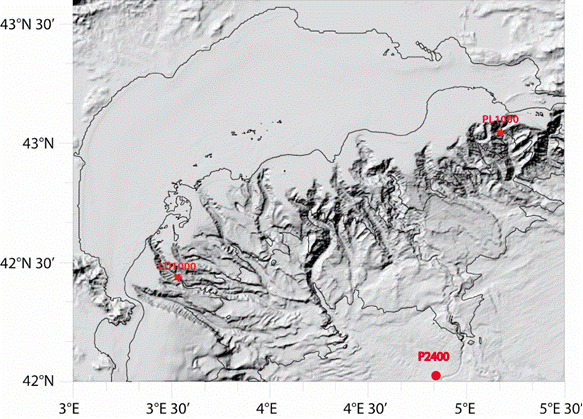
Characterizing the variability of hydrological and current measurement features and particulate fluxes in two canyons of Le Planier (station PL1000) and Lacaze-Duthiers (station LD1000) located at the easternmost and westernmost tips of the Gulf of Lion. Since 2011, setting up a long-term frame of reference in the convection zone - PPS3 trap, buoy zone and LION line.
-
Characterizing the variability of hydrological and current features and particulate fluxes on the continental rise of the Gulf of Lion and in the deep convection zone. Monitoring of deep benthic communities in the western canyons and on the continental rise of the Gulf of Lion. This cruise was associated with the HERMES and EXTREMA projects.
-
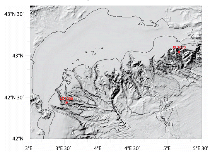
Characterizing the variability of hydrological and current measurement features and particulate fluxes in two canyons of Le Planier (station PL1000) and Lacaze-Duthiers (station LD1000) located at the easternmost and westernmost tips of the Gulf of Lion.
-
Characterizing the variability of hydrology and currentology features and particulate fluxes in the two canyons of Planier (station PL1000) and Lacaze-Duthiers (station LD1000), located at the eastern and western edges of the Gulf of Lion.
-
The main objective of the MOOSE-GE cruises is to observe the annual evolution of the Northwestern Mediterranean Sea in the context of the climate change and anthropogenic pressure in order to be able to detect and identify long-term environmental trend and anomalies of the marine ecosystem. The annual cruise focuses on moorings maintenance and hydrology, biogeochemistry and biology monitoring of the Northwestern Mediterranean basin. It aims to follow variability of water masses properties (LIW and WMDW) and biogeochemical and biological content related to these water masses.
-

The oceanographic vessel Vizconde de Eza developed its first research campaign in Galicia as a result of the unfortunate accident and sinking of the Prestige oil tanker. In January of 2003, this project was undertaken to estimate the impact produced by the discharge of hydrocarbon on the demersal communities on the continental shelf of Galicia, in soft bottoms between 90 and 500 m, testing new acoustic methods for the detection of fuel the depths fixed. This multidisciplinary campaign took place over eight days on board the B / O Vizconde de Eza in the area of the continental shelf between the Ría de Muros and La Coruña. The study of the main members of the bottom communities (infauna, epifauna, suprabenths and benthic and demersal macrofauna) was included, for which 20 sampling stations were established located in the three strata of the standardized trawl campaigns (70 - 120, 121 - 200 and 201 - 500 meters).
-
This third investigation of the spillage of fuel in waters of Galicia and the Cantabrian Sea intended to continue the study of the impact of oil spills. In this edition, the monitoring of the process of recovery of ecosystems and exploited resources involved a study during spring flowering, period of higher production, to quantify the changes in the patterns of distribution and abundance of the communities. This campaign of 'evaluation of the impact of the Prestige discharges on the ecosystem of the platform and its fishing resources in spring time' was attended by researchers from the IEO, SGPM and CSIC. GOALS The general objective was to estimate the impact produced by the Prestige discharge on the demersal and benthic communities present on the continental shelf of Galicia, in soft bottoms between 35 and 500 meters. These communities are subject to considerable fishing exploitation and sustain the economy of numerous coastal towns of Galicia and the Cantabrian Sea. At the same time, geophysical studies were included, aimed at improving the knowledge of the funds of the internal platform, essential for carrying out sampling operations. The study was articulated around the following objectives: WORK AREA A multidisciplinary campaign of 16 days was proposed in the area of the platform between the Ría de Vigo and the mouth of the Bidasoa river. The study was conducted in affected areas of the continental shelf of Galicia and the Cantabrian Sea in funds between 35 and 500 m. To this end, a series of sampling stations arranged in radials and located in five geographical sectors and three depth layers (71-120, 121-200 and 201-500 m) were established, which corresponded to those of the historical series of survey campaigns. of the IEO (following figure). In areas of special interest due to the importance of the discharges, hauls were made at less than 70 m.
-
Coinciding with the development of the project, Friday, April 2, 500 days have passed since a 26-year-old monocoque tanker, loaded with 77,000 tons of fuel, split in two. The Prestige sank 260 km from the Cies Islands, in the Vigo estuary, generating a first spot of 5,000 tons of fuel. This campaign analyzes the effects produced by the spillage of the Prestige hydrocarbon on the ecosystem of the continental shelf of Galicia. OBJECTIVES Multidisciplinary campaign that monitored the impact of oil spills on demersal and benthic communities in funds between 70 and 500 m. Likewise, the geophysical study of the worst known areas of the platform was undertaken, such as the rocky areas, which are, nevertheless, of great ecological and commercial importance, and possible areas of sedimentary deposit that can be points of accumulation and retention of fuel
-
Characterizing the variability of hydrological and current features and particulate fluxes on the continental rise of the Gulf of Lion and in the deep convection zone. Monitoring of deep benthic communities in the western canyons and on the continental rise of the Gulf of Lion.
-
Retrieving an array of moored current meters recording subtidal circulation on the ocean margins of the Bay of Biscay (Armorican and Aquitaine shelves and slopes). Related hydrological measurements taken. This falls under the ASPEX project.